Introduction
Dhaulagiri round Trek an adventure that takes you from low warm paddy fields to cooler alpine hills and ending at the arctic zone of ice and glaciers at Dhaulagiri base camp.
Dhaulagiri Round Trek, the walking grade is from adventurous to challenging in snow conditions. One of the tough walks truly an adventure for veteran trekkers and adventurers. Trekkers will surely enjoy this fascinating walk on Dhaulagiri Round with ever-present mountain views includes Annapurna Circuit Himalaya and other range of peaks which makes this adventure enjoyable and memorable.
Highlights
- From low warm farm areas to alpine hills to reach the arctic zone of ice and glaciers.
- Adventure on off the beaten tracks on least ventured by few groups of trekker’s Camping on the foot of world 7th highest Mt. Dhaulagiri and its huge Ice-Falls.
- Explore remote farm villages inhabited by Magar the hill tribe of western Nepal.
- Trek beyond villages into sheer wilderness within the pristine dense alpine forest.
- Follow raging Mygdi River right up to its glacial source at Dhaulagiri base camp.
- Cross over high French Pass to scenic Hidden valley enclosed by majestic peaks.
Mountain Views on this wonderful Dhaulagiri Adventure Trek
On this adventure where trekkers can enjoy the great panorama on walks as well on a drive with views of Mt. Dhaulagiri (8, 167 m), Mustang Himal with Mt. Annapurna- I (8, 09 m) Mt. Manaslu (8,163 m), Mt. Annapurna II (7,937 m.), Mt. Annapurna III (7, 555 m), Mt. Annapurna IV (7,525 m), Mt. Annapurna South (7, 219 m), Mt. Nilgiri (7,041 m), Mt. Hiunchuli (6, 441 m), Mt. Lamjung Himal (6, 986 m), Tukuche peak (6, 920 m), to Tilicho peak (7, 134 m).
A short overview of Dhaulagiri Round Trek
Dhaulagiri Round Trek a great journey within Far North Western Nepal Himalaya. Where walks lead you to far remote corners away from villages and human settlement for a week in complete harmony with mountains and pristine nature. Walk to Dhaulagiri Round Trek starts with overland from the scenic and lovely city at Pokhara, where the drive takes you to the western end of Myagdi district around farm village at Darbang past Beni town, following the great Myagdi River.
As our adventure begins from low-warm farmland reaching mid-hills around Magar people village hill tribe of Dhaulagiri region. Slowly our walk leads much higher elevation into densely forested areas of tall rhododendron and pine trees within total isolation. Dhaulagiri Round Trek slowly leads away from green vegetation towards fields of glaciers with huge boulders of ice, walking with care to reach Dhaulagiri base camp. Right beneath the world’s seventh-highest Mt. Dhaulagiri rise high at 8,167 m high, with close views of its great massive Ice-Falls next to the camp.
From the base camp heading to cross scenic high French pass at above 5, 360 m high facing tremendous views of Dhaulagiri, Tukuche, Mukut, and other range of adjoining peaks. Enjoying a fabulous panorama from the highest spot of the adventure. Then downhill to the wonderful large field at Hidden Valley enclosed within a series of peaks. From here walk leads to cross another pass called Thapa / Dhampus pass to reach the Mustang area at Kaligandaki valley in Marpha.
Marpha one of the most charming village around the Himalaya. The next day, an exciting drive takes you to lovely Pokhara by its serene Phewa Lake, where our magnificent adventure Dhaulagiri Round Trek completes.
Outline Itinerary
Day 01: Drive from Pokhara to Darbang (1,110m/3641ft) via Beni(830 m/2723ft) -06 hrs.
Day 02: Darbang to Phaliyagaon (1850 m/6069ft) – 05 hrs.
Day 03: Phaliyagaon to Jugepani 1750 m- 05 hrs
Day 04: Jugepani to Bagar (2,080m/6824ft) -05 hrs.
Day 05: Bagar to Dobhan Kharka (2,520m/6267ft)-06 hours.
Day 06: Dobhan Kharka to Sallaghari /Khola camp (3445m/113202ft) -06 hrs.
Day 07: Sallaghari to Italian Base camp 3660 m.- 4/5 hrs
Day 08: Rest day at Italian Base Camp.
Day 09: Italian base camp to Japanese Camp (3890m/12762ft) -05 hrs.
Day 10: Japanese Camp to Dhaulagiri Base Camp (4,748m/15577ft)– 06 hrs.
Day 11: Dhaulagiri Base Camp to Hidden Valley (5140m/16863ft) via French Pass (5,360m/17585ft).-06/07hrs
Day 12: Hidden Valley to Elevation Camp(4,930m/16174ft)– 05 hrs.
Day 13: Elevation Camp to Marpha (2, 670m/8759ft) – 07/08 hours.
Day 14: Drive from Marpha to Pokhara (860m/2821ft).6/7hrs
Detail Itinerary
Day 01: Drive from Pokhara to Darbang (1,110 m /3, 641 feet) via Beni town (830 m / 2,723 feet) - 06 hrs.
Start the morning with an interesting overland journey, after a hearty breakfast in the hotel, the drive on four-wheel or similar according to group size. Drive takes you beyond scenic Pokhara city and the valley heading towards west, on good Beni / Baglung and Pokhara highway.
Enjoy views of the high Annapurna Himalaya range of peaks with majestic Machhapuchare, the fish-tail peak most of the way as drive climbs up towards Naudanda and Kande villages. After a few hours drives downhill past Lumle village to reach Nayapul and then at Kusma town towards Beni, a large major town and headquarter of Mygdi district.
With a possible stop for lunch, and then continue to drive further west on a dirt road, the motorable road been constructed past a few years ago. As drive follows Mygdi River past farm areas and rural villages to reach Darbang. A nice farm village slowly turning into a town, after the road has been built that leads further west to Dhorpatan.
Darbang, located on a shelf of Mygdi River with few local guesthouses and a simple lodge for overnight accommodation. Having time to browse around the village and observe local traditional farm life, of Magar people the ethnic hill tribe of Western Nepal.
Day 02: Darbang to Phaliya-Gaon (1, 850 m / 6, 069 feet) - 05 hrs.
Our first-day walk begins following the Mygdi River upstream, walking by the bank past many small scattered farm hamlets and villages with few slow ups and down, within a cool shade patch of forest to reach our lunch spot near the Mygdi River.
Our camping cook will prepare fresh hot light lunch with some refreshment, afternoon walk leads into few dense tree lines and farm areas to reach Phaliya-Gaon for overnight camping.
Day 03: Trek from Phaliya-Gaon to Jugepani 1,750 m - 05 hours.
After our first overnight in a tented camp, breakfast prepared by our expert cook and kitchen staff, having the first refreshment of the day carry on trekking to reach another small farm village at Jugepani.
Morning walks on a pleasant trail through farm fields and terraces where rice paddy and other main crops are harvested around this sub-tropical climate. As trek leads by the riverside, and then after few hours of good walks leaving the river behind, with a short climb into a small forested area, with a possible lunch break.
Having a refreshing stop, the afternoon walk continues over the farm area encountering few smaller villages, and then reach our overnight camp at Jugepani, a small rural farm village with a vast farm field surrounded by thick forest.
Day 04: Trek from Jugepani to Bagar 2,080 m / 6, 824 feet -04 hrs.
The morning after a good breakfast, start the day to reach at Bagar a small farm Magar tribe village, begins with a pleasant walk for an hour and then heading for a steep climb towards a ridge top.
A climb of an hour on reaching the top, rest of the walk on downhill through the forest on a small path towards Bagar for lunch and overnight camp, where tents are set up near the school compound.
Herewith time for a short hike and enjoy the rest of the afternoon relaxing, this is the last village or a permanent settlement for a week till we reach Marpha on the other side of Dhaulagiri massif, where the popular Annapurna circuit route meets at Kaligandaki within Mustang area.
Day 05: Trek from Bagar to Dobhan Kharka 2,520 m / 6, 267 feet-06 hours.
After a pleasant overnight stop, the morning after breakfast set off from this last village of Mygdi district, as walk head north on leaving farm fields of Bagar village. Where trail leads into the cool shade of a forest for an hour and then climbs towards a forested ridge covered with bamboo, oaks, and rhododendron trees.
Walking above Mygdi River, after the steep haul for an hour or more and then head downhill on the narrow trail within a dense forest of pines and rhododendron to reach at Dobhan Kharka for overnight camp by a small stream that joins with Mygdi River further down.
Dobhan Kharka a small temporary settlement of local cattle herders, a place for grazing domestic animals, at present in the high season of trekking houses a small tea shops and a shelter for porters as well for trekkers, located amidst dense forest surrounding.
Day 06: Trek from Dobhan Kharka to Sallaghari /Khola camp at 3, 445 m / 11, 3202 feet-06 hrs.
From Dobhan Kharka, in the cool morning out main adventure begins as a walk leads to cross an unstable wooden bridge over a stream one of the tributaries of the raging Mygdi River.
After safely crossing the bridge, heading into a thickly forested area filled with tall rhododendron, oaks, and magnolia, hemlock with pine trees. Walk for the whole day within forest surroundings to reach Sallaghari after a good day trek. This area also called Chartare or Bhaise Kharka, a grazing meadow with small Shepherd's temporary huts and a shelter where our overnight camp is set on a small grassy field.
Day 07: Trek from Sallaghari to Italian Base camp 3,660 m - 04 hrs.
Today, a short walk of few hours to reach our next camp at Italian base camp, after a peaceful overnight within dense tree lines. The morning starts crossing a few smaller streams and into a thick forest.
Walk on a gradual path with few short ups and down and then after 2-3 hours of walk head for a slow climb to reach a glaciated valley at a place called Italian Base Camp, located at the bottom of towering South West Flank of Mt. Dhaulagiri massif peak.
At Italian Base Camp for lunch and an overnight stop, where tents are pitched on best available level ground close to moraine and glaciers with time for a short walk around this scenic spot. An amazing place was so close to tree lines and yet barren with moraine of glaciers.
Day 08: Rest day at Italian Base Camp.
Trekking for several days, nearly a week-long a deserving rest day for leisure hike to support acclimatization, before heading much higher elevation towards Dhaulagiri base camp and over high French Pass.
Enjoy late breakfast, and the morning sun as this area gets warmer during afternoon time, the morning is cold with late sunlight that reaches our campsite.
From this vantage point where you can take a walk to view more of the Dhaulagiri satellite and adjoining peaks with Mt. Dhaulagiri South Face flank, with Putha Huinchuli, Ganapathi. The Italian Camp got its name in the early 1970s where the Italian Expedition to Mt. Dhaulagiri set their interim camp right on this spot.
Day 09: From Italian base camp to Japanese Camp 3, 890 m /12, 762 feet -04 hrs.
After a lovely and pleasant rest at Italian Camp, from here the onward adventure begins walking over glaciated section and moraine with rocky areas, and then on top of a small ridge with some grass.
The walk leads on a gradual narrow path above Dhaulagiri glacier, where Mygdi River starts, and then reach a place called Pakhaban also called a Japanese camp. Where Japanese expeditions to Mt. Dhaulagiri camped on this isolated spot in between Dhaulagiri South West Flank and Manapathi Himal. A short day walk of few hours for lunch and overnight camp facing grand views of Dhaulagiri southwest Face with a huge wall of Tsaurabong Peak.
Day 10: Trek from Japanese Camp to Dhaulagiri Base Camp (4,748 m /15, 577 feet - 06 hrs.
From this scenic camp on a grassy small field, our adventure begins heading uphill in between the huge bulk of mountain range and within a deep glacial gorge above the source of Mygdi River. Today, the cook will prepare a packed lunch as there is no good place to cook within glacier and moraine, where a safe path has to be maintained by our expert guide and the area can be misleading.
Trek continues with gradual up, where path meanders to cross over moraine and icebergs and glacial ponds, from here onward follow our lead guide as the path has to be made, every season the trail gets washed by the movement of glaciers and rock-fall. After negotiating across vast glaciers and moraine then finally reach our overnight destination at Dhaulagiri Base Camp, located right beneath the towering West Face of Mt. Dhaulagiri and its massive Ice-Fall and glaciers.
Truly, one of the strenuous walks of the adventure going through the glacier to reach past ice and glacier at Dhaulagiri base camp for overnight camp, one of the highlights of this adventure. The camp is set on a rocky level area with a close face of Mt. Dhaulagiri-I which towers at 8,167 m / 26, 795 feet stands as the world's 7th highest Mountain. Which was first summited by the Swiss Expedition and with Nepalese Sherpa guide on May 13th, 1960.
The camp offers a grand view of Dhaulagiri Ice-Fall with Tukuche peak and west peaks of Dhaulagiri II (7,751 m.), Dhaulagiri III (7,715 m.) includes Dhaulagiri IV (7,618 m.).
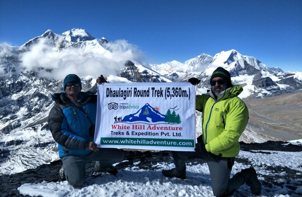
Day 11: Trek from Dhaulagiri Base Camp to Hidden Valley 5, 140 m / 16, 863 feet via French Pass 5, 360 m / 17, 585 feet-06 hrs.
The adventure starts with a morning slow walk on a gravel rocky path with close views of Tukuche peak, as the trek continues heading to the highest spot to cross over French pass at above 5,360 m high. The climb is not hard or difficult with some steep up to reach on top, festooned with Buddhist prayer flags, and stone cairn facing views of surrounding high mountain, after glorious views. A short descend walk of few hours to reach a wide grassy field at Hidden Valley for overnight camp.
Hidden valley surround by an array of snow-peaks extends towards Tukuche peaks, with Dhaulagiri-I, the camp offers magnificent views of Sita Chuchura, Mukut Himal, and Tashi Kang 5,386 meters with Dhampus peak.
Day 12: Trek from Hidden Valley to Elevation Camp 4, 930 m - 05 hrs.
After a great exciting time at Dhaulagiri Base Camp and at Hidden Valley, morning walk on narrow gravel winding path, as trailheads towards the east at the end of Hidden Valley (in snow condition the path can be misleading and arduous).
Walking for few hours with a gentle moderate walk then cross our last pass of the adventure over Thapa / Dhampus pass located above 5,250 m high, from the top enjoy the excellent panorama of Annapurna Himal with Nilgiris peaks.
From the top, a long downhill walks to reach Elevation Camp or Yak Kharka, also known as Alu bari, (potato field) for overnight camp. As descend lose much altitude reaching back to green vegetation of Juniper, Burberry, and rhododendron bushes with views of snow-capped peaks.
Day 13: Trek from Elevation Camp to Marpha 2, 670 m / 8, 759 feet - 07 hrs.
From this nice scenic camp facing grand views of Annapurna and Dhaulagiri range of peaks, today the last day walk of the adventure. As our final route heads more downhill within tall coniferous tree-lines with a big drop of 1,200 m to reach around Kaligandaki River valley, where our nice and pleasant last final walk completes on reaching Marpha village, located within Mustang area and Kaligandaki River valley.
At Marpha for overnight last overnight stop and into a nice cozy lodge, after more than a week in tented camping. Marpha one of the jewel of a village and most charming places where all houses are painted white with neat stone-paved streets and well-kept lodges. At Marpha celebrate last night dinner with local apple products cider, brandy and juice this area from Jomsom, Marpha to Larjung is famous for delicious apples.
Day 14: Drive from Marpha to Pokhara 860 m / 2, 821 feet -07 hrs.
After an enjoyable overnight in the comfort of a nice warm lodge and the great hospitality of local Thakali people, the ethnic tribe of Lower Mustang and Kaligandaki River valley.
Marpha is close to Jomsom situated on the ancient Trans-Himalaya Salt and Caravan Route of Nepal and Tibet that extends beyond Upper Mustang. Enjoy the last breakfast in the mountain village, and then depart for Pokhara taking a jeep ride or four-wheel drive, an interesting and very scenic journey to reach on world deepest gorge of Kaligandaki River near Lete village.
The gorge is situated in between towering peaks of Annapurna-I and Dhaulagiri-I that makes the world's deepest gorge. The drive continues past Ghasa to reach the low warm area within the sub-tropical climate, drive reach a lovely Tatopani village a place with natural hot-spring.
From Tatopani village follows Kaligandaki River downstream to reach Beni and Baglung town, and then on good tarmac highway to reach at scenic Pokhara by the serene Phewa Lake, a great lovely spot to conclude our marvelous adventure around Dhaulagiri Trekking.
Cost Information
Cost Includes
- All needed transport By Bus.
- Hotel picks up/drop by private vehicle.
- Food (Breakfast/Lunch/Dinner) and Tea Coffee Everyday During a Trek.
- Mountain Accommodation (Tea houses/camping)
- Excellent Guide and Porters (Food, Salary, Insurance, equipment).
- All needed Mountain Trekking Permit.
- First AID and Medical Kit.
- Free international airport peak up and drop Service.
Cost Excludes
- Beer,cola,mineral water,hot water , Wi-Fi ,battery charges ,hot shower etc.
- Your personal equipment.
- Your Travel insurance.
- Tips for Guide and Porter.
Equipment
FOR HEAD
- Sun hat / Scarf
- Sun glasses and Head lightFor Upper Body
- Water Proof Jacket
- Down Jacket / Warm Jacket
- Light Weight T-shirt (At least 1 pair)
FOR LOWER BODY
- Water Proof Pants
- Running tights
- Light Weight Pant
- For Hand
- Gloves
FOR FEET
- Thin Inner socks (At least 2 pairs)
- Woolen socks
- Trekking boots (preferred comfortable boots)
OTHER ACCESSORIES
- Sleeping bag
- Water bottle etc
- Suncream
- Water purification tablets
- Toiletries (Toiletpaperetc)
- Warm hat
- Trekking Bag Etc.
Frequently Asked Questions About Dhaulagiri Round Trek
FAQ (Frequently Asked Questions):
01: How tough is Around Dhaulagiri Trekking?
Depends on your fitness level to cope with steep climb and descend where walk leads you over glaciers and ice fields for some days, as well crossing high French Pass at 5,357 m and Thapa / Dhampus pass 5,250 m high.
It is not tough walks once you start this adventure with good physical exercise before joining on this trip, where the grade is from adventurous to challenging (in snow conditions).
02: When is the right time to book for the trek Around Dhaulagiri?
April and May with September to November months, when days are clear for views and walk chances of snow sometimes during the trek even in right time of the year. April to May where hills are alive with wild flowers in full bloom especially the rhododendron (national flower of Nepal) of various species, where most morning
till mid day are clear, where clouds can gather in late afternoon with chances of rains lower area, with snow on higher altitude sometimes. Cold in night and morning time as well in shade higher up, after leaving green
forested area till Marpha village is reached.
03: Around Dhaulagiri Trekking can Itinerary day be shorten?
Yes, beside our standard Itinerary of 15 days walks, one can shorten from Marpha village, where one can take overland journey to Pokhara or take a short flight from Jomsom, after ending the trek at Marpha village making it few days shorter.
04: Instead of climbing up to Ghorepani can we take vehicle ride to Pokhara?
From Tatopani village a place with natural hot spring one can break the journey taking drive from Tatopani to Pokhara; this will shorten the treks for 2 days instead going uphill to Ghorepani and Poon Hill.
05: What age do you prefer for Dhaulagiri Round Trek?
Person from above 20 to 55 years of age where above 50 years of age some insurance company does not allow the medical cover, even though one is fit for the trek and adventure. Beside insurance policy where from 20 to little over 50 years can join on this adventure as long one is physically fit, with strong mind and health, as this is one of great adventurous walks can lead to challenging in some snow conditions.
06: Is it Camping or Lodge / Tea House treks?
After Pokhara till Marpha village where accommodation will be in two men spacious tents with full camping providing with separate kitchen unit of cook- kitchen staff, guide and strong porters to carry the camping equipment and foods including your heavy baggage.
Meals are cooked in Kerosene / LP Gas stoves served with care of proper hygiene and well balanced food required on this wonderful adventurous treks, where sleeping bags and mats provided as per company trip cost that provides with includes and excludes.
Reviews
Dhaulagiri Round Trekking Information
Around Dhaulagiri a great wonderful adventure that takes you to the heart of the world's 7th highest Mt. Dhaulagiri, one of the massive ranges located in Far Western Nepal Himalaya at the height of 8,167 m and 26,795 ft. The mountain first climbed on May 13th, 1960 by Swiss Expeditions with Nepalese Nyima and Nawang Dorji Sherpa since then the summit of Mt. Dhaulagiri frequently climbed every year, Mt. Dhaulagiri can be seen from Pokhara and on treks to Ghorepani and Poon Hill overlooking its Easter Face, a huge mountain with series of peaks that adjoins.
Dhaulagiri located around the remote and isolated Nepal Far West where walk leads you away from villages and human settlement for some days in complete harmony with giant peaks and around remorseless fields of ice and glacier. An adventure in total wilderness crossing high French pass with Dhampus and Thapa pass to reach back into human civilization at Marpha within Kaligandaki River valley around Lower Mustang.
Best time for the trek from April to June and September to November in high snow arduous job to find the right path, where expert and experienced guide can lead you safe with enjoyable times on Around Dhaulagiri Trekking.