A firsthand experience of what it is like to trek to Everest Base Camp, one of the highest mountains in the world.
We had left Kala Patthar Hill behind, Khumbu Glacier and had been walking for more than two hours along with the rock parts, a massive which marks the beginning of the real hiking, hence Nepal’s Mountain.
The black rocks, blue lakes with beautiful yak babies grazing on them were quickly replaced. Extremely nice Khumbu Giger, the Biggest glacier in Everest Region, behind you world highest mountain standing just opposite of you.
Likewise, Our steps heading towards the Base Camp. Physically, we were tired. Mentally, so exciting to reach the lap of Everest. Suddenly, we were in Base camp, 5,353 meters above sea level. On the massive rocks, written welcome to Everest Base Camp Trek.
It was such a long way but, thanks to the warm greetings from White Hill Adventure Guide Pasang and offered us drinks warm water, and some chocolate, it was totally worth it.
As we kept advancing, we left our luggage at the teahouse in Gorakshep Village. Along the way, we were walking cameras with trekking pools.
At the Everest Base Camp, there isn’t any sleeping place, teahouses. Only some tents, people who are preparing to the summit on the top.
Lifetime achievement! Then we back to the lodge for overnight sleep. The sun goes getting down behind the mountains. Same way back, easier than up. We walked 1 hour 45 minutes, arrived at our Budhha Lodge in Gorakshep.
Hence, our main goal is for tomorrow morning to the summit on Kalapattar. Kalapattar 5,545 meters from sea level, this best Mt. Everest viewpoint place in the world.
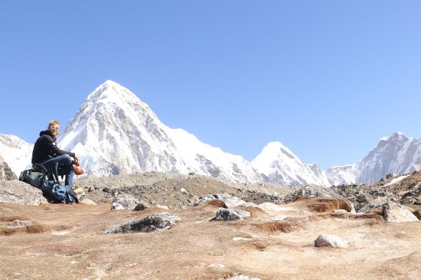
Meaningful stayed at Gorakhsep over the 5,000 meters. The next day, early in the morning, we woke up then started the walk to Kalapatthar hill for 3 hours up steps.
Finally, we have reached the hills at sunrise time. The sun seems to rise on the head of Mt. Everest. In a few kilometers far distance, we have breathtaking views of Everest. More than 50 % of the upper part, we could see Everest views from Kalapattar hills. Helipad middle part of the hill, Lake Glacier, and scenic mountain views.
Mt. Everest is an imposing 8,848 – meter shared between Nepal and Tibet. It is the biggest mountain in the World. Moreover, Mt. Lhotse is the fourth highest mountain in the world at 8,516 meters, after Everest, K2, and Kangchenjunga. Mount Pumori, Nuptse, and peaks are famous for climbing in September to November seasons.

Trekking to Everest Base Camp
Before traveling to South Asia, I didn’t really know about trekking and hiking. I had heard of the Everest and Himalayas in Nepal. But I didn’t have a fixed idea of any specific trekking route and place.
However, the Everest Base Camp trek had been on my thoughts for years and was definitely, something I didn’t want to miss when I went backpacking in Nepal.
You probably wonder why I knew about Everest and not the other hiking places. Well, the Base Camp is the easiest 5,553 meters to reach on foot.
Nevertheless, this doesn’t mean that you can hike it without your backpacking trekking shoes and gear. The high altitude is a real issue and only well-prepared people can reach the Everest Base Camp.
Basically, Most of the tourists organized base camp trekking before arrival in Kathmandu. Your agency booked Kathmandu to Lukla flight tickets, guide, Sherpa, and Permits.
Therefore, we also booked everything with white hill adventure six months ago like other hikers. We were taken care of by our guide and the guide has been working under the company.
Practical Information for trekking to the Everest Base Camp trek
Here’s some good information to have in case you are thinking of trekking to Everest Base Camp in Nepal. Kathmandu is the biggest city and capital city in Nepal. Normally, this base camp trek needed twelve days from Kathmandu to Kathmandu.
Outline Itinerary for Everest Base Camp trek in Nepal
Day 01: Kathmandu to Lukla flight – 45 minutes, trek to Phakding.
Day 02: Phakding to Namche Bazaar.
Day 03: Rest in Namche Bazaar.
Day 04: Namche to Tengboche Monastery -6 hours.
Day 05: Tengboche to Dingboche Village -4 hours.
Day 06: Dingboche rest.
Day 07: Dingboche to lobuche – 4 hours.
Day 08: Lobuche to Gorakshep, day hike to EBC- 6 hours.
Day 09: Gorakshep to Kala patthar, hike down to Pheriche -8 hours.
Day 10: Pheruche to Namche – 7 hours.
Day 11: Namche to Lukla -6 hours.
Day 12: Fly back to Kathmandu.

When to visit Everest Base Camp in Nepal?
However, travelers have done Everest base camp trekking in four seasons in Nepal, But two seasons are the best time in a year. The Autumn season is one of the best times for the base camp trek. Normally, these months (Sep-Oct-Nov) are shining days. This is time to Finish the hot season and start the cold season. Mountain views are clear, no cloudy, and no fuggy. The second-best season is spring. The months (March -April –May) are green and blooming on the nature into the mountain. Usually, the weather is also good this time. That’s why the spring season is the best time for Everest base camp hiking.
However, when I came here in Mid-November, the Kala Patthar was covered in ice and snow. My normal water bottle was frozen when I was hiking up to Kala Patthar hill. So, I can’t imagine what it is like during colder seasons.
Altitude and Acclimatization
Katmandu, the starting point, is at above 1,300 meters already and the base camp is around 5,335 meters, and Kala Patthar little higher, it is about 5,555 meters from sea level.
So, you really need to be prepared for high altitude.
As per our outline itinerary, we had two days of acclimatization in Namche bazaar (3,450 meters) and Dingboche (4,410 meters). Our body needs to adjust to the local environment.
We had been trekking in both Peru and Pakistan for a long time, so we were more than used to the high altitude. However, if you just came to the region, it is recommended to drink a lot of water, and wearing warm clothes is the best prevention for altitude sickness.
Food and teahouse/sleep
You may not need to carry food for the base camp trek. Teahouse offers you breakfast, lunch, and dinner. Whatever you want, like tea, coffee, mo: mo, pasta, pizza, yak steak, and Dhal-Bhat. One of them, Dhal-Bhat is an old interesting dish, it is Nepali typical meal. You paid one fixed price and ask many times for food at the same price. I.e. One plate mo: mo is ten pieces, if you want more mo: mo than one plate, you have to pay extra money. This is the universal rule but in Nepal not a similar culture for dhal-bhat.
Tea houses, most of the lodge are cozy and family teahouses. We felt like a homestay. People are smiling and happy faces, always welcoming guests. In Nepali slogan; Guest is God! In Sanskrit; Atithi Devo bhava.
Teahouse peoples say; Namaste! It’s mean Hello, Hi, Hey…!
In Teahouse, delicious food is available. Besides them, Hot showers, sharing toilets, Wi-fi, a Mobile charging place, a net, and a clear bedroom are welcoming for travelers.
How many days are needed for Base Camp from Ktm?
You need a minimum of 12 days and a maximum 0f 14. One night will stay Gorakshep to visit Base Camp and, another day early morning hiking to Kala Patthar. Perhaps, do a one more day stay in Gorakshep for Base Camp and Kala Patthar. If you want to go to the Kala Patthar or explore the area further, you will need 1 more additional days.
Personally, we spent 1 night there. On the first day, we walked all the way new Everest Base Camp and Old Everest Base Camp, where we spent 2 hours.
On the following day, we walked to the Kala Pattar for sun-rise views of Everest. The same day back to Pheriche, descending. We met other trekkers, who hiked Kala Patthar for sunset views. Kala Patthar and Base Camp are the optional destinations, which one first you would like to do. We thought, our option is the best for the Everest views. We did afternoon time base camp and morning time Kala Patthar hills.
During the 12 days trek, we walked 8 days and a half ascending, including two days rest in a Namche and Dingboche. And 3 days and half the same way back to downhill. Way to Base camp walk very slowly and enjoy fully because of altitude and Scenic Mountain views.
Sometimes, you may need extra days due to Lukla no flight and weather challenges. But in our case, we didn’t have any problem. Weathers are clean and beautiful valley, rivers and mountain views. We heart, Lukla airport was closed for 6/7 days in the winter season. That’s one of the reasons, we chose the month of Nov.
Your first day and last day are necessary to be a lucky day. The first day, early morning flight from Kathmandu to Lukla, 45 minutes flight by Yeti and Sita airlines. We flew by Tara airlines, the pilot was local from Namche bazaar. He was a really good and experienced pilot, we got.
We met some tourists who were hiring helicopters due to the Lukla flight being canceled. As they told us, they paid per person 400 USD extra for a helicopter with an airplane ticket. Early morning flight more chances to get in Lukla due to weather. Normally, the everyday flight goes to Lukla at good trekking in seasons.
On the last day, before arriving at Lukla our guide manage and changed the flight ticket for an early morning flight for Kathmandu. He called from Namche bazaar for the agency to make an early morning flight.
In Lukla, there is also an airline’s office. It is open every day at 3:00 pm for the next day’s flight. We can change our ticket to Lukla when we arrived from Namche.
Likely or unlikely; your 12 days Everest Base Camp trekking can be 1 /2 days longer. It depends on your physical, mental, and weather condition.
Finally, we finished our trek on time in 12 days. Everything was super!
Famous Mountain and peaks in the Everest region
Everest is the King of the Himalayas. It is located in Mahalangur Himal. Nearby Everest three other mountains are over eight thousand meters high. Forth highest Mt Lhotse, 8,516 meters, Firth highest Mt Makalu, 8463 meters, and Six highest Mt Cho Yu, 8,188 meters.
Moreover, many mountains are over 7,000 meters high. Mt. Nuptse, Pumori, Ama Dablam are popular mountains for climbing. World-famous trekking peaks are here. Thus are Island Peak, Mera Peak, and Lobuche peaks. They are very famous trekking peaks for climbing.
Likewise, Mt. Everest summiteer started climbing from peak to mountain. They don’t go directly to Everest before climbing other small peaks. Climber climb step by step.
Trekkers enjoy seeing these beautiful mountains and peaks. Everest base camp treks give you the opportunity to enjoy with all above the mountains and peaks.
Famous villages and places in Everest
Lukla
Lukla is a gateway to the Khumbu region. Everest base camp trek is started from Lukla, 2846 meters. This is the entry and exit point of trekking. In Lukla, neat and clean tea houses and lodges are available. Wi-fi, internet, hot shower, bakery shop, supper market, book shop, Airlines office, souvenir shop, pool house, bar, and restaurant easily get in Lukla. This is one of the busy cities in the Everest region. Tenzing hilly located is in lukla. Trekkers need al list one after finishing trek what’s why this is a busy and crowded place.
We took, our porter from Lukla. We left him the same place. We saw many porters and guide looking for jobs in Lukla. We preferred, taking a guide from Kathmandu.
Namche
Namche is the biggest city in the Everest region. Its 3,450 meters high from sea level. Namche bazaar is a junction point for trekkers. Before going to high places, peoples stay one more night at Namche for Acclimatization. From Namche city, peoples go to many different places. Everest three high passes trek, Gokyo Ri trek, Cho-la pass trek, Amphu laptsa pass trek, and Everest base camp trekkers stayed in Namche.

In Namche, facilities teahouse and hotel. A small and beautiful city in mountain transportation is yaks and horse.
Moreover, Porters carry food and goods. You can see a small Sherpa are carrying heavy loads more than 100 kg. Namche is a beautiful city on the way to Everest Base Camp Trek.
Tengboche
Tengboche is famous for its Monastery as well as nice views of Mt Everest. This monastery is most famous in Nepal.
The monastery is the leading Buddhist center in the Khumbu region with a residing Rinpoche who blesses Pilgrims, climbers, and trekkers passing through.
Every October, Tengboche Monastery hosts the colorful Mani Rimdu festival, which is a ritual with a religious gathering, songs, and cultural dance of the lives of legendary figures.

Small Tengboche village surrounded by colorful rhododendron, Azaleas, and pine forest. At the monastery, evening and morning time Lama prayed by mantra. Neat and clean teahouse available at Tengboche village.
Dingboche
Dingboche village is located in a beautiful valley. Dingboche is 4,430 meters high from sea level. In this village, many tea houses and lodges as well as Bhatti. Bhatti means porter restaurant, they can get local alcohol and the food is cheap and best.
Dingboche is a busy village, trekkers stay one more night for rest/ Acclimatization.
Dingboche is a junction place because some of the people came back from Everest Base Camp, people came from Island peak climbing, and some of them are from Amphu Laptsa Pass.
This is a sunny and windy palace on the way to Base Camp. Dingboche is the home of Yaks, Horses, Tibetan Snowcock, and snow leopard. You have the opportunity to see all of them.
On Acclimatization day, day hike to Nangkartshang Peak (5,083 meters). It will better prepare you for the climb. Such as elevation gain, distance and tips.
Pheriche
Pheriche and Dingboche are one hour far. Both are Sherpa homeland places. In Pheriche, there is a hospital. They give free information about high-altitude sickness and treatment. In Pheriche, more than 25 neat and clean tea houses are available. Trekkers stay in Pheriche when they came back from Base Camp.
Lobuche
In Lobuche, 4,900 meters high you might feel uneasy for breathing. No need to be a worry. If you have any problem, they can inform your guide and team. When hiking up, the oxygen level is low in the environment due to planets. In Lobuche village, there are no trees and plants. The village is like the desert. Snow Caps Mountain is beautiful.
Seven lodges and teahouses are welcoming for tourists. We slept at pyramid lodge in Lobuche.
Gorekshep
Gorakshep is the highest altitude sleep during the 12 days trek. It was 5,164 meters high. Over the Gorakshep, there are not any tea houses and lodges. In Everest Base Camp, there are no lodge and tea houses. Everest expedition peoples sleep in the tent, over the Gorakshep Village. In Gorakshep four teahouses and lodges are available.

From Gorakshep people do Kala Patthar, Everest Base Camp, and Everest Summit as well. So, Gorakshep village is busy sports in the high season. Here is Wi-fi and phone signal at noontime. This is a beautiful village, which is the situated lap of Everest.
Lukla to Everest Base Camp Miles/distance
Follow the way to EVEREST BASE CAMP trekking route 39 miles, 62 Kilometers, and 8 and half days walking as per our trekking Itinerary.
Lukla to Everest Base Camp 15 miles, 24.1 KM, Aerial distance. By helicopter 7/8 minutes.
Moreover, Lukla is situated 2,846 meters middle part of the hill. This village, 35 minutes far from Kathmandu by flight. Kathmandu to Lukla is 137 kilometers and 85 miles far. If you choose overland, you need two days jeep driving and 7 hours walking also from Kathmandu.
Everest Base Camp is located in Nepal, it is called the south base camp, with an altitude of 5,364 m. At the base camp, there are not any teahouses and lodges. Gorakshep is the last village, it is situated 5,164 meters high.
However, Everest Base Camp to Lukla takes 3 days walk. Downhill is easy than uphill, with no necessary Acclimatization and rest for altitude.
One mountain has three different names:
1, Everest:
2, Sagarmatha:
3, Chomolungma
Check INN time in Kathmandu Airport
Domestic flight, Kathmandu to Lukla will start at 6:15 am in high season. Where you stay in Kathmandu, depends on your location to the Tribhuwan Internation Airport.
Kathmandu, Thamel to airport 7 Kilometers, 25 minutes driver and 10 USD for Taxi. One hour before your flight time, you need to check-in at the domestic airport.
In our case, our flight was 7:15 by tara airlines. We had breakfast at the hotel then we leave the hotel by 5:30 am for the airport.
We arrived at Lukla at 8:00 am, then we have started our hiking to Phadking for that day.
Equipment and backpacking
Equipment is one of the most important weapons to get success for the Everest base camp trek.
The whole year, snow and ice are available at base camp. In the wintertime, the base camp temperature is -30 to -40 degrees at night time. But you stay at tea houses, at the teahouse they provide your warm blankets for overnight.
For the afternoon hiking time, you can wear a T-shirt, Half paint, Thermal paint, trouser. In the evening and morning time will be colder, You need a Down jacket, trekking paints, wind paints, wind jackets, warm socks, gloves, Warm Skull Cap, neck gaiter, hat, thermal, trekking poles, sunglass, sun creams, flashlight, water bottle, Money- Pouch, toilet paper, chargers, sandals, camera, gaiters (optional), Solar power Bank, Trekking map, and Day pack.
Moreover, Trekking bags, shoes, and sleeping bags are necessary for your trekking equipment list. However, good trekking gear helps to get success your trip. Before starting your Everest base camp trek, you have to check your list in Kathmandu. What’s you have or haven’t. You can buy and rent around Thamel trekking shops.
List of equipment: (photo)
Medicine and health
Fitness is also a necessary thing for this Everest Base Camp Trek. Every day, you need to walk 4/5 hours on average. But on Acclimatization day, not necessary to walk. Garlic soup, Ginger soup are best for health in high-altitude areas.
Unfortunately, my husband had diarrhea in Tengboche, our guide have the medical box, and he gave medicine to him then husband’s problem gone and became a normal condition.
Therefore, you need to carry some medicine along the way for yourself. High altitude Diamox, paracetamol, brufen, Imodium, bandage, Detrol, handy plus tape, Knee ankle bandage, and so on.
However, oxygen is not necessary to carry for the base camp trek. Over the base camp, those people who are going climbing mountains use Oxygen when they needed. Trekkers, not use oxygen in normal conditions.
Moreover, if you have any problem, in Pheriche there is a hospital. Pheriche is 4 hours far from Everest base camp, and 3 hours from Gorakshep.
Downward, in Khumjung, Namche, and Lukla have a medical/small hospital available.
The district hospital is an in salleri bazaar. As I was, thus people who were sickness/high altitude they chatter helicopter. Every trekker have insurance, the insurance over helicopter and medical.
For high-altitude patients, they need to go downhill, at least 500 meters low then high altitude possibility will be done.
We are with our guide and porters. We were like a nice family. Our guide really looks after us every time. He gave us many ideas about altitude, how to be saved by ourselves.
We booked this trip with White hill adventure also for take care of us. Health and medicine are most important for the Everest Base Camp trek.
List of medicine:
Diamox: (Photo)
Paracetamol: (Photo)
Brufen: (Photo)
Imodium: (Photo)
Bandage: (Photo)
Detrol: (Photo)
Handy plus tape: (Photo)
Knee ankle bandage: (Photo)
Vaccine and PCR test
The vaccine is necessary to travel around the world. Nepal Government giving authority to any vaccinated peoples can visit Nepal. But the vaccine must be authorized by WHO.
PCR test is valid 48 hours before your flight to Nepal. Vaccinated and PCR negative report traveler no need to stay hotel Quentin and home Quentin.
How to get on Arrival Visa for Everest Base Camp trek
Tourists can get easily on Arrival visa at the Kathmandu Airport. Which is Cost 30 USD for 15 days. 50 USD for 1 month visa in Nepal.
Entrance fee for Everest base camp trek in Nepal.
Everest Base Camp trek is in Sagarmatha National Park. Manjo in the entry point of National Park. Sagarmatha National park is a park of Nepal that has been made to the UNESCO World Heritage Sites. It is the country’s first national park which was inscribed as a Natural World Heritage site in 1979.
This national park entrance fee is 30 USD or 3,390 rupees for foreigners, for SAARC (South Asian Association for Regional Cooperation) is 1,695 rupees per person.
Similarly, TIMS cards cost 2000 rupees for trekkers. One-time buy, it’s valid till you are not exiting.
Sagarmatha National park permit, you can buy in Kathmandu at Nepal tourism board office, Brikuti mandap or you can buy on the way to Everest Base camp trek at Manjo.
Food and menu for Everest Base Camp Trek in Nepal
Continental delicious food is available in the Everest region. Indian, Tibetan, and Nepali typical meals are provided at hotels and teahouses.
Tibetan bread, Nepali dhal-bhat, Sherpa stew are local foods, which are tasty as well.
Every lodge, they have experienced cooks who can cook delicious any item food. You can look menu, and give an order whatever you like.
In high season, sometimes the kitchen is too busy. You have to give an order an hour before you eat. In the hotel, vegetable and non-vegetable food are available.
We are non-vegetarian, we had really good food during our trip. Our guide was a good cook and waiter. He used to serve food to us at lunch and dinner. But it is not possible to get fresh juice over the Namche Bazaar.
Tips for guide/porters for the Everest Base Camp trek in Nepal
Tipping is not Nepali culture, this European culture. Most European and Americans like hiking, they came to Nepal. They did trekking, end of the trip they gave tips to guide and porter for thanks. This tips system became a culture. Guide and porters hope tip with tourist end of the trek. The tip is not fixed, how much you need to give them. As you like from your heart. Some tourist also gives clothes, good and things as a tip. We gave some money and my hiking boots for porters. I would like to say again, thanks to the agency who help us to meet a nice guide and porters.
Lukla Airport
The Lukla airport is popular because it is considered the starting point of the Everest base camp trek. Lukla is gateway of Khumbu region. There are daily flights between Lukla and Kathmandu during daylight hours in good weather.
Tenzing Hillary Airport also known as Lukla airport, is the busiest airport in Nepal for the trekking season. It gained worldwide fame as it was rated the most dangerous airport in the world.
Lukla airport is situated 2,800 meters high from sea level but Kathmandu is 1,350 meters high.
Experienced pilots and airlines team, will make your nice and successful journey. If there is bad weather, they will cancel the flight. It means, Airlines Company and pilot team don’t like to take any risk.
Local transportation option
Local transportation is not available for the Everest Base Camp trek. Nearby Lukla, the place’s name is Khari Khola jeep goes from Kathmandu. It is one day camp, from Khari Khola to Lukla, 6 hours walk.
Kathmandu to Kharikhola takes 2 days by jeep. Kathmandu to Salleri drive, 12 hours then change another jeep to Khari Khola, 9 hours.
This is a jeep option for Everest Base Camp trekking. Another option is by helicopter. It is a costly but supper fast transportation option.
Kathmandu to Lukla flight is one of the best decisions for the Everest base camp trek. We choose the same option which was an easy flight in Lukla.
Details Itinerary of Everest Base Camp Trek in Nepal:
Day 01: Kathmandu to Lukla flight then hike to Phakding (Everest Base Camp Trek)
Flight start: Kathmandu (1,350 meters/ 4,430 feet).
Flight time: 35 minutes.
Trek Start Point: Lukla (2,840 meters/ 9,318 feet)
Trek Ending Point: Phakding (2,610 meters/8,563 feet)
Elevation Gain: –230 meters/ -755 feet.
Distance: 8.2 kilometers/ 5.1 miles.
Trekking Duration: 3 hours.
The early morning flight takes from Kathmandu to Lukla. Most tourists stay in Thamel at hotels and apartments. Thamel to domestic airport, 30 minutes driving by Cap/car. We stayed at Sapana garden home. We leave at 5:30 am for our 7:15 am flight to Lukla.
Likewise, we flew for Lukla. It takes 35 minutes flight from Kathmandu, 85 miles. Tara airlines made us a nice flight. On the way to Lukla, we saw Gaurishanker (7,135 meters), Tashi Lapcha, Kongde, and many more peaks on the left side.
Near Lukla, Lamjura Hill (3,600 meters) most challenging hill for Lukla airport at a cloudy time. Planes have to cross Lamjura to get into Lukla.
A small and busy town Lukla, welcoming tourists. Kathmandu was warm, suddenly in half an hour, we feel cold. Get down at Tenzing- Hillary airport at 7:50 am then we met our porter at the airport. We went to a restaurant then had coffee, Guide introduced each-others to the porter.
Our guide Pasang showed the trekking maps and gave us a short brief about today’s programs at coffee time. We have to walk the Northside of Lukla to Phakding. Phakding is only 3 hours far from Lukla. We are going to stay at Phakding. All the way flat. Phakding is 200 meters lower altitude than Lukla.
Hence, we started walking to Phaking for today. In Lukla gate, there is statue of Pasang Lambu Sherpa. She is a legend woman in the Everest region. She was the first Mt.Everest climber woman.
We crossed the village, monastery, Rhondendon, and alpine forest. Along the way, we followed Dudh Kosi River. This Kosi river is originally from high altitude area of Mt Everest. Likewise, Passed Chaurikharka, Chheplung village, Thado Koshi Gaon, Nursing, and Chhuthwa village then Phakding Village.
Phadking village was the bank of a river on the Lukla site, where we stayed. In Phaking, we slept beer garden lodge. They have a hot shower, Wi-fi, Warm Dining hall. They cooked delicious food.
Day 02: Phakding to Namche Bazaar via Check Post
Trek Start Point: Phakding (2,610 meters/ 8,563 feet)
Trek Ending Point: Namche Bazaar (3,440 meters/11,286 feet)
Elevation Gain: 830 meters/ 2,723 feet.
Distance: 10.9 kilometers/ 6.8 miles.
Trekking Duration: 6/7 hours
The second day is quite a long day than the first day. It will be 6 to 7 hours hiking to the Namche Bazaar.
We woke up at 6:00 am, we had breakfast at 6:30 am then the trek started at 8:00 am.
Thereafter, we crossed the Suspension bridge of Dudh Kosi River. The forest of Alpine, bamboo, and rhododendron make us easily walk on the shadow.
Nonetheless, we were turning left and right of Kosi River over crossed bridges. We arrived at the check post of Sagarmatha national park. In Manjo village, 2,835 meters entrance point.
We had been waiting for our turn in the traffic of tourists. It takes half an hour to take a permit of the national park then we continued to further.
We stopped for lunch at Joresale Village. Till Joresale village, the trail was slightly uphill. It is a two and half hours walk from Phadking.
Furthermore, we crossed suspension bridges of the Dudh Kosi River. From Larja Dobhan to Namche Bazaar route is steeply uphill, 2 hours. Larja suspension bridge, build on two depth hill. During the walking time, trekkers must be careful with donkey and Dzo (hybrid between the yak and domestic cattle). These animals are the main transportation of mountains. They were walking the same trail with us. Sometimes, they push people and are careful with aggressive animals.
Meanwhile, we saw Mt. Everest first time on the way to Namche Bazaar. The middle path on the hill, small tea shop, toilet, and seating place. One hour more walking to the Namche bazaar. Finally, we arrived at Namche at 3:30 pm. It was a beautiful hilly city and a Colorful hotel/lodge. We slept in Khumbu Lodge.
Day 03: Rest/ Acclimatization in Namche Bazaar
Trek Start and Ending Point: Namche Bazaar (3,440 meters/11,286 feet).
Day Hiking Place: Everest View Hotel (3,880 meters/12,730 feet) and Khumjung Village (3,790 meters/12,434 feet).
Elevation Gain: 440 meters/ 1,444 feet.
Distance: 5.4 kilometers/ 3.4 miles.
Hiking Duration: 3 hours
The Acclimatization day, wake up late. Today will not be busy day like other days. We hike up to Khumjung village (3,790 meters) and Everest view point hotel. It will be 2 /3 hours walking trip.
As you told you, we woke up 7:00 am then took breakfast at hotel. We were start hiking to Everest view point hotel without luggage and porters. We had camera, water, and day pack. Namche to Khumjung take 1 hour 30 minute walks. North of Namche Bazzar, there is big local village where is school and hospital built by Sir Edmun Hillary, Khumjung Village.
Khumjung village and Everest view point hotel are 30 minutes walking distance far. Everest View point hotel, where you can see a stunning panoramic view of Mt. Everest from your room window.
But we don’t sleep here, we were just there for day hiking. And we had coffee at hotel with smoking Mt. Everest views.
Moreover, Tengboche monastery, Manjo village, Thamaserku, Island peak, Ama dablam, Lhotse and Nuptse are monument views.
Besides of beautiful nature, In Khumjung monastery, there is Yeti skull. Yeti is snow man, who lived in Himalaya thousands of years ago. But no one seen to them.
The Everest climber got skull then they were given to them Monastery to put on.
Khumjung is a biggest Sherpa’s village in Khumbu area where high school and hospital as well. They growth foods like Potato, wheat, and fapar. Yak and horse are local transportation. Local village, Khumjung sightseeing at rest.
Thereafter, we turned back to Namche Bazaar, Having lunch, Rest at hotel. Overnight stay at Namche bazaar.
Day 04: Namche Bazaar to Tengboche Monastery
Trek Start Point: Namche Bazaar (3,440 meters/11,286 feet).
Trek Ending Point: Tengboche (3,860 meters/12,664 feet).
Elevation Gain: 878 meters/ 2,881 feet.
Distance: 9.6 kilometers/ 6.0 miles.
Trekking Duration: 5/6 hours.
Namche Bazaar (3,440 meters) to Tengboche Manastery (3,860 meters) 6 hours walking, downhill, uphill and flat. Hiking towards North-east from Namche bazaar to Tengboche.
You are into the national park, You can see wild animals are grazing inside the bushes. Musk deer, Himalayan Tahr, Red Panda, and Snow leopard are wild animals of national park.
Occasionally, trekkers meet wild animals on the trail while hiking to Tengboche village. Sometimes, we can hear deer are barking inside the jungle.
Namche to Tengboche, there are two trails you can meet after walking one hour. If you turn left hand side, directly you will be Gokyo Lake (4,750 meters) via Phortse, Dole and Machhermo in three days. Gokyo Lake trek – 11 days is also very famous destination in Everest region.
We continued, our trek to Tengboche village, have catch right side trail. There are sign and arrow for Everest base camp and Gokyo village. Eventually, we can see towards Tengboche monastery on top of another hill. Besides of them, our guide Pasang mention everything about today trip.
Finally, we arrived Tengboche Village at 2:00 pm. We saw beautiful sunset views on Mt. Everest, Lhotse and Nuptse. At the evening, we joined puja with lama at Monastery. We had nice dinner and stay overnight at Tengboche Village, Good night!
Day 05: Tengboche Village to Dingboche Village
Trek Starting Point: Tengboche (3,860 meters/12,664 feet).
Trek Ending Point: Dingboche (4,410 meters/14,469 feet).
Elevation Gain: 697 meters/ 2,287 feet.
Distance: 10.5 kilometers/ 6.5 miles.
Trekking Duration: 4/5 hours.
Every night at before to go to the bed, we talked about our tomorrow program, ours guide gave us briefing for next day programs. However, from Tengboche to Dingboche village walking 3/ 4 hours along the way to Imja Khola.
Once you leave Tengboche, You will first began a decent into the forest as you pass the small village of Diboche. This is another village option to stay overnight if you are not able to find room in Tengboche.
One past Deboche, you will continue along as you gain some elevation and will eventually pas by a wall of inscribed stones and mane. Soon after that you will cross a suspension bridge to take you the left hand side of the valley as you walk along the valley. Out in front of you will be some vast Views of Ama Dablam and others valley views as well as landscape.
After two hours walk you will approach the Pangboche Village, where you can see and enjoy views of the Everest and Loptse out in front of you. One the way of Everest Base Camp, another a beautiful place and route is Ama Dablam Base Camp.
If you have one more day extra time on your trip, you can add a day visit Ama Dablam Base Camp. Check out with guide to learn more about the trek.
We were continue on with our day as we leave Panboche Village and head future up the Valley.
Likewise, we passed by the village of Shomare, which is last village before reaching Dingboche Village. As we continued along we were slowly pass Ama Dablam and others peaks views.
Once we arrived in the Dingboche village, head on over to a teahouse, where we stayed for the two nights.
Day 06: Rest/ Acclimatization in Dingboche.
Trek Starting and Ending point: Dingboche (4,410 meters/14,469 feet).
Day Hiking Place: Nangkartshang Peak (5,083 meters/16,677 feet).
Elevation Gain: 673 meters/ 2,208 feet.
Distance: 5.1 kilometers/ 3.2 miles.
Hiking Duration: 5 hours.
On day 6th of the Everest Base Camp trek is rest day in Dingboche Village. But you don’t stay whole day in same place.
Meaningfully, today we hike to Nangkarshang Peak (5083 meters) and come back at same teahouse. We hike up above the valley as you get to enjoy some of the scenic views during the multi day trail.
Nangkartshang Peak is at (5083 meters) and Dingboche (4,410 meters). Therefore, the hike will have our body more prepared for the next days at the higher elevation and Everest Base Camp. From top of the hill, you can see panoramic Imja Khola Valley and mountain views.
Meanwhile, you can see yaks pasture, Mane, Chortens and Tibetan prayer flags.
Moreover, Throughout the way you can take views of Mt. Makalu, Lhotse, Cho Oyu, Island Peak, Ama Dablam, among plenty other high peaks.
At evening time in dining hall yak sheet fire camp. Making warm, having nice dinner and seep overnight.
Day 07: Dingboche Village to Lobuche.
Trek Start Point: Dingboche (4,410 meters/14,469 feet).
Trek Ending Point: Lobuche (4,910 meters/16,109 feet).
Elevation Gain: 500 meters/ 1,640 feet.
Distance: 7.9 kilometers/ 4.9 miles.
Trekking Duration: 4/5 hours.
We were passed Diboche, Somare village, bridge and yak’s pasture. We leave the Everest Base Camp trek, today as we head to north through the Thukla Pass.
Moreover, Slide uphill to the Thukla village takes 2 hours from Dingboche Village. The beautiful views of Taboche, Lobuche, Pomuri, and Nuptse.
Yak’s babies grazing with mum, and horse Pasture. On the way mane and prayer flags.
However, Thukla pass is little challenging uphill during the today’s trek. It’s take an hour then we can see some grave of mountaineers’ top of Thukla hill. From hill, you can see nice Pheruche valley view and mountains.
Thukla to Labuche village takes, one hour more walk then finally we reach our today’s destination.
Alternative route to Lobuche via Kongma La Pass (5,535 m)
Day 08: Lobuche to Gorakshep Village.
Trek Start Point: Lobuche (4,910 meters/16,109 feet).
Trek Ending Point: Gorakshep (5,125 meters/16,810 feet).
Elevation Gain: 705 meters/ 2,313 feet.
Distance: 4.5 kilometers/ 2.8 miles.
Trekking Duration: 3 hours.
Alternative trekking route in Everest Region:
Its day 8 of our trek to Everest Base Camp. Today’s at noon time, we will be in Everest Base Camp.
Likewise, we will have lunch at Gorakshep village. We leave our bag pack/luggage at Gorakhsep’s teahouse. With water, some snacks, chocolate continue hike to Everest Base Camp then back to hotel.
Gorakshep to Everest Base Camp take 3 hours walk to go and 2 hours need to back hotel. Wearing warm clothes and drinking plenty warm/hot water are best idea for high altitude.
Meanwhile, we will have amazing Mountain View, and cross khumbu glacier.
Finally, we reach Everest Base Camp, 5,364 meters. It is a Lifetime achievement. Thanks God, we are now in World highest mountain Base Camp.
We enjoy, an hour in Base Camp then back to hotel at Gorakshep. Gorakshep is a highest village in our during the 12 days trek. In Gorakhsep, four teahouses/lodges available for tourist. We stay at Budhha lodge for overnight. At Gorakshep, there are several teahouse for Overnight. Good Night guys!
Day 08: Lobuche to Gorakshep Village.
Trek Start Point: Lobuche (4,910 meters/16,109 feet).
Trek Ending Point: Gorakshep (5,125 meters/16,810 feet).
Elevation Gain: 705 meters/ 2,313 feet.
Distance: 4.5 kilometers/ 2.8 miles.
Trekking Duration: 3 hours.
In Everest Base Camp Trek, every day is memorable day. Today, the day 8th is a most important day like before.
Likewise, From Lobuche to Gorakshep hiking is slide up hill. Yak and horse are main transportation for carry foods and goods.
You might feel quite difficult to walk fast when we are going uphill due to getting less oxygen. Oxygen will be getting less above the 16,000 feet.
Meaningfully, you don’t need oxygen to use for Everest Base Camp Hiking. Just Paracetamol, Diamox and flexon are enough. If trekkers have altitude sickness problems, they can go at list 2,000 feets downhill. After that, Sick people can feel better.
However, you will not feel tired because of mind blowing views of Everest, Lhotse, Pumori and Sherpa life style.
Today’s your journey will be till Everest Base Camp then back to Gorakshep for overnight. In Everest Base Camp, there are no any teahouse and lodge. Only some tents, its make sleep for climbers.
In Everest Base Camp, a great single of world’s highest mountain base camp. You will have photography as well as having some snacks if you are carry on from down.
Actually, you will not have chance to see any mountain views from Everest base camp. It’s only having experience of base camp.
On the way back, through the Khumbu glacier. Arrived at Gorakhsep for overnight stay. Next day morning hike to Kalapattar.
Day 9 : Kala Patthar Sunrise then back to Pheruche Village:
Trail Name: Kala Patthar | Kalapathar
Starting: Gorak Shep.
Ending Point: Pheruche.
Gorak Shep Elevation: 16,814 feet / 5,125 meters
Mid Point: Kala Patthar Summit
Kala Patthar Elevation: 18,220 feet / 5,555 meters
Distance: 2.3 miles / 3.7 kilometers (round trip)
Duration: 3 hours (round trip)
Elevation Gain: 1,362 feet / 415 meters
After hiking for 8 days from Lukla to Everest Base Camp, it is time to all the way back down after Kalapattar Hill Climb. Most people, hike up Kalapathar on the morning time.The day of 9th, before heading back down the valley to the village of Pheriche, we have stunning views Mt Everest.
Kalapatthar is one of the best views point of Mt Everest by overland. That’s why people come to Kalapatthar for sunrise time as well as sun set for golden Everest views.
From Kalapatthar to Mt. Everest distance is only 10 KM by air. By walking/climbing it’s take more than three weeks to go and back from base camp.
Kala patthar is best view point of Mt. Everest, Lhotse, Nuptse, Pumori, frozen lakes and Khum khung Glacier.
However, after enjoying on the top of Kala patthar views point then back to the gorakshep village. You will collect bag from hotel then trek down to Pheruche via lobuche village.
Day 10: Pheriche Village to Namche Bazar:
Trek Start Point: Pheruche (4,240 meters/13,911 feet).
Trek Ending Point: Namche Bazzar (3,440 meters/11,286 feet).
Elevation Gain: – 600 meters/ -2,625 feet.
Distance: 19.9 kilometers/ 12.1 miles.
Trekking Duration: 7 hours.
Today, you will walk all the way down. Hiking passed Tengboche Monastry, Somare village, bridge and yak’s pasture as well as rhododendron and alpine forest.
Walk in to the bank river, Mt. Ama Dablam is standing in front of you when you.
You were passes mountain views, now Sherpa cultural and life style. Monastery, Gumpa, Prayer flags are part of Buddhist religious.
Likewise, you arrived Namche bazzar from higher part Himalaya. So, Namche is beautiful Sherpa City in Everest region. Which is busy city in high trekking season.
Day 11: Namche Bazzar to Lukla Airport:
Trek Start Point: Namche Bazzar (3,440 meters/11,286 feet).
Trek Ending Point: (2,840 meters/ 9,318 feet)
Elevation Gain: – 600 meters/ -2,625 feet.
Distance: 19.1 kilometers/ 11.9 miles.
Trekking Duration: 7 hours.
This is our last day in Sagarmatha national park. Where we started our trek, same place we are going to end today.
However, we are going to miss our lifetime achievement place. From Namche to Lukla, all the way is down hills. Cross the Sunpencious Bridge, passes National park check post, Manjo, Phakding then arrive at lukla bazzar.
Finally, you finished 11 days walk till Kala patthar and Everest Base Camp. Lukla is that place where you starting and ending point for Everest Base Camp trek. Overnight stay in lukla, next day morning fly flack to Kathmandu.
Day 12: Lukla to Kathmandu flight then transfer to hotel in Thamel
Flight Start Point: Lukla (2,840 meters/ 9,318 feet)
Flight End Point: Kathmandu (1,350 meters/ 4,430 feet
Flight time: 35 minutes.
Elevation Gain: 1,490 meters/ 7,968 feet.

Lukla Airport is a small domestic airport in Everest Region. Its take 35 minutes flight to Kathmandu. Three small aircraft landed in this tiny airport.
Meaningfully, Lukla to Kathmandu flight will be scenic mountain flights. Finally, Arrival in Kathmandu after 12 days Everest Base Camp Trek.